


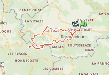
15736114-chemin_de_rocamadour_et_des_deux_valle-version2

Nordic33
User GUIDE

Length
15.8 km

Max alt
280 m

Uphill gradient
464 m
Km-Effort
22 km

Min alt
114 m

Downhill gradient
462 m
Boucle
Yes
Creation date :
2022-10-29 09:48:19.6
Updated on :
2022-10-29 09:51:56.49
4h59
Difficulty : Medium

FREE GPS app for hiking
 SityTrail
IGN / Geographical institutes
SityTrail Plus
The world is yours!
About
Trail Walking of 15.8 km to be discovered at Occitania, Lot, Rocamadour. This trail is proposed by Nordic33.
Positioning
Country:
France
Region :
Occitania
Department/Province :
Lot
Municipality :
Rocamadour
Location:
Unknown
Start:(Dec)
Start:(UTM)
391356 ; 4962107 (31T) N.
Comments