


Chantal JM

CatherinePerrin
User
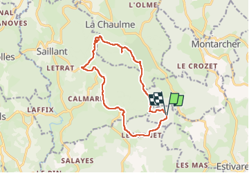

Length
14.5 km

Max alt
1199 m

Uphill gradient
379 m
Km-Effort
19.5 km

Min alt
933 m

Downhill gradient
378 m
Boucle
Yes
Creation date :
2021-09-29 07:38:55.376
Updated on :
2022-10-30 09:15:11.987
5h28
Difficulty : Very difficult

FREE GPS app for hiking
 SityTrail
IGN / Geographical institutes
SityTrail Plus
The world is yours!
About
Trail Walking of 14.5 km to be discovered at Auvergne-Rhône-Alpes, Loire, Estivareilles. This trail is proposed by CatherinePerrin.
Positioning
Country:
France
Region :
Auvergne-Rhône-Alpes
Department/Province :
Loire
Municipality :
Estivareilles
Location:
Unknown
Start:(Dec)
Start:(UTM)
575982 ; 5031666 (31T) N.
Comments