


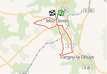
Montlevon du 30-10-2022

VANDERPUTTENMi
User GUIDE

Length
6.1 km

Max alt
213 m

Uphill gradient
121 m
Km-Effort
7.7 km

Min alt
123 m

Downhill gradient
118 m
Boucle
Yes
Creation date :
2022-10-30 08:58:11.256
Updated on :
2022-11-01 17:56:25.717
1h34
Difficulty : Medium

FREE GPS app for hiking
 SityTrail
IGN / Geographical institutes
SityTrail Plus
The world is yours!
About
Trail Walking of 6.1 km to be discovered at Hauts-de-France, Aisne, Montlevon. This trail is proposed by VANDERPUTTENMi.
Positioning
Country:
France
Region :
Hauts-de-France
Department/Province :
Aisne
Municipality :
Montlevon
Location:
Unknown
Start:(Dec)
Start:(UTM)
539513 ; 5423837 (31U) N.
Comments