


Bernarvillé Ungersberg 13 km

vaillantjm
User
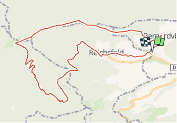

Length
12.9 km

Max alt
897 m

Uphill gradient
636 m
Km-Effort
21 km

Min alt
285 m

Downhill gradient
637 m
Boucle
Yes
Creation date :
2022-10-30 09:01:41.756
Updated on :
2022-10-31 08:07:08.315
4h40
Difficulty : Difficult

FREE GPS app for hiking
 SityTrail
IGN / Geographical institutes
SityTrail Plus
The world is yours!
About
Trail Walking of 12.9 km to be discovered at Grand Est, Bas-Rhin, Bernardvillé. This trail is proposed by vaillantjm.
Positioning
Country:
France
Region :
Grand Est
Department/Province :
Bas-Rhin
Municipality :
Bernardvillé
Location:
Unknown
Start:(Dec)
Start:(UTM)
381487 ; 5358433 (32U) N.
Comments