


La montagne de vieille morte

Roger Philippe Wallez
User GUIDE
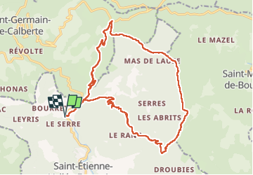

Length
23 km

Max alt
915 m

Uphill gradient
889 m
Km-Effort
35 km

Min alt
262 m

Downhill gradient
886 m
Boucle
Yes
Creation date :
2022-10-30 08:50:43.0
Updated on :
2022-10-30 16:41:29.983
6h56
Difficulty : Very difficult

FREE GPS app for hiking
 SityTrail
IGN / Geographical institutes
SityTrail Plus
The world is yours!
About
Trail Walking of 23 km to be discovered at Occitania, Lozère, Saint-Étienne-Vallée-Française. This trail is proposed by Roger Philippe Wallez.
Description
Rdv pont de Negase
Positioning
Country:
France
Region :
Occitania
Department/Province :
Lozère
Municipality :
Saint-Étienne-Vallée-Française
Location:
Unknown
Start:(Dec)
Start:(UTM)
566526 ; 4892927 (31T) N.
Comments