


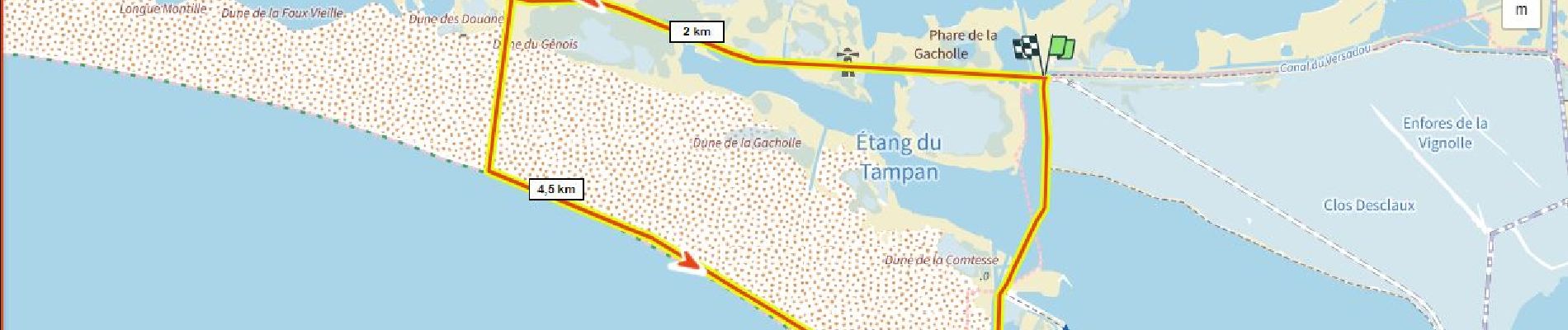
Phare de la Gacholle et tour de l' étang du Tampon

ericberlin
User

Length
10.3 km

Max alt
3 m

Uphill gradient
21 m
Km-Effort
10.6 km

Min alt
-4 m

Downhill gradient
21 m
Boucle
Yes
Creation date :
2022-10-30 16:52:41.695
Updated on :
2023-06-05 15:35:47.4
2h24
Difficulty : Medium

FREE GPS app for hiking
 SityTrail
IGN / Geographical institutes
SityTrail Plus
The world is yours!
About
Trail Walking of 10.3 km to be discovered at Provence-Alpes-Côte d'Azur, Bouches-du-Rhône, Saintes-Maries-de-la-Mer. This trail is proposed by ericberlin.
Description
A tester en hiver (moins de moustiques!) un jour sans vent.
Bac: http://www.smtdr.fr/horaires-tarifs/
Photos


Positioning
Country:
France
Region :
Provence-Alpes-Côte d'Azur
Department/Province :
Bouches-du-Rhône
Municipality :
Saintes-Maries-de-la-Mer
Location:
Unknown
Start:(Dec)
Start:(UTM)
628170 ; 4812456 (31T) N.
Comments