


cascade blanche

brigitBB26
User
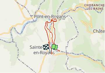

Length
9.1 km

Max alt
303 m

Uphill gradient
248 m
Km-Effort
12.4 km

Min alt
197 m

Downhill gradient
248 m
Boucle
Yes
Creation date :
2022-10-31 09:36:07.218
Updated on :
2022-10-31 14:27:30.993
4h50
Difficulty : Difficult

FREE GPS app for hiking
 SityTrail
IGN / Geographical institutes
SityTrail Plus
The world is yours!
About
Trail Walking of 9.1 km to be discovered at Auvergne-Rhône-Alpes, Drôme, Sainte-Eulalie-en-Royans. This trail is proposed by brigitBB26.
Positioning
Country:
France
Region :
Auvergne-Rhône-Alpes
Department/Province :
Drôme
Municipality :
Sainte-Eulalie-en-Royans
Location:
Unknown
Start:(Dec)
Start:(UTM)
684517 ; 4990815 (31T) N.
Comments