


3110

maxEA65
User
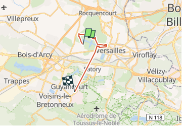

Length
11.2 km

Max alt
180 m

Uphill gradient
201 m
Km-Effort
13.7 km

Min alt
103 m

Downhill gradient
157 m
Boucle
No
Creation date :
2022-10-31 14:04:33.473
Updated on :
2022-10-31 16:17:04.557
2h12
Difficulty : Difficult

FREE GPS app for hiking
 SityTrail
IGN / Geographical institutes
SityTrail Plus
The world is yours!
About
Trail Walking of 11.2 km to be discovered at Ile-de-France, Yvelines, Versailles. This trail is proposed by maxEA65.
Positioning
Country:
France
Region :
Ile-de-France
Department/Province :
Yvelines
Municipality :
Versailles
Location:
Unknown
Start:(Dec)
Start:(UTM)
433140 ; 5406600 (31U) N.
Comments