


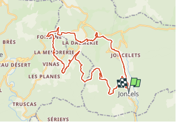
joncels Fombine

Alain28/01
User

Length
24 km

Max alt
719 m

Uphill gradient
898 m
Km-Effort
36 km

Min alt
390 m

Downhill gradient
898 m
Boucle
Yes
Creation date :
2022-11-01 18:04:07.095
Updated on :
2022-11-01 18:05:25.18
8h10
Difficulty : Very difficult

FREE GPS app for hiking
 SityTrail
IGN / Geographical institutes
SityTrail Plus
The world is yours!
About
Trail Walking of 24 km to be discovered at Occitania, Hérault, Joncels. This trail is proposed by Alain28/01.
Positioning
Country:
France
Region :
Occitania
Department/Province :
Hérault
Municipality :
Joncels
Location:
Unknown
Start:(Dec)
Start:(UTM)
515658 ; 4842736 (31T) N.
Comments