


2 jours 2014

frank12
User
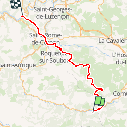

Length
48 km

Max alt
832 m

Uphill gradient
1075 m
Km-Effort
63 km

Min alt
320 m

Downhill gradient
1295 m
Boucle
No
Creation date :
2014-12-10 00:00:00.0
Updated on :
2014-12-10 00:00:00.0
2h00
Difficulty : Unknown

FREE GPS app for hiking
 SityTrail
IGN / Geographical institutes
SityTrail Plus
The world is yours!
About
Trail Other activity of 48 km to be discovered at Occitania, Aveyron, Fondamente. This trail is proposed by frank12.
Description
fondamente saint-rome du tarn
Positioning
Country:
France
Region :
Occitania
Department/Province :
Aveyron
Municipality :
Fondamente
Location:
Unknown
Start:(Dec)
Start:(UTM)
507726 ; 4856759 (31T) N.
Comments