


lestrade et thoueks

CASSISFRAMBOISE
User
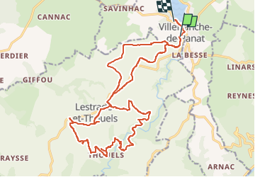

Length
26 km

Max alt
792 m

Uphill gradient
655 m
Km-Effort
34 km

Min alt
514 m

Downhill gradient
639 m
Boucle
No
Creation date :
2022-11-02 13:11:56.098
Updated on :
2022-11-02 16:41:42.822
3h26
Difficulty : Difficult

FREE GPS app for hiking
 SityTrail
IGN / Geographical institutes
SityTrail Plus
The world is yours!
About
Trail Mountain bike of 26 km to be discovered at Occitania, Aveyron, Villefranche-de-Panat. This trail is proposed by CASSISFRAMBOISE.
Positioning
Country:
France
Region :
Occitania
Department/Province :
Aveyron
Municipality :
Villefranche-de-Panat
Location:
Unknown
Start:(Dec)
Start:(UTM)
476111 ; 4881486 (31T) N.
Comments