


depart chenecey buillon,cateau ruiné,pont de chatillon

gerardmicheline
User
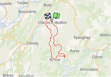

Length
22 km

Max alt
498 m

Uphill gradient
461 m
Km-Effort
28 km

Min alt
273 m

Downhill gradient
463 m
Boucle
Yes
Creation date :
2022-11-04 16:54:20.001
Updated on :
2022-11-04 16:56:01.377
6h24
Difficulty : Very difficult

FREE GPS app for hiking
 SityTrail
IGN / Geographical institutes
SityTrail Plus
The world is yours!
About
Trail Walking of 22 km to be discovered at Bourgogne-Franche-Comté, Doubs. This trail is proposed by gerardmicheline.
Positioning
Country:
France
Region :
Bourgogne-Franche-Comté
Department/Province :
Doubs
Municipality :
Unknown
Location:
Unknown
Start:(Dec)
Start:(UTM)
724280 ; 5224890 (31T) N.
Comments