


st joseph - st Philippe par la route forestière

XavierFaidix
User
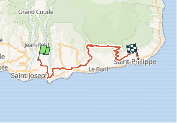

Length
42 km

Max alt
707 m

Uphill gradient
1029 m
Km-Effort
57 km

Min alt
34 m

Downhill gradient
1312 m
Boucle
No
Creation date :
2022-11-03 05:36:15.221
Updated on :
2022-11-07 09:33:19.469
4h30
Difficulty : Medium

FREE GPS app for hiking
 SityTrail
IGN / Geographical institutes
SityTrail Plus
The world is yours!
About
Trail Mountain bike of 42 km to be discovered at Réunion, Unknown, Saint-Joseph. This trail is proposed by XavierFaidix.
Description
l'ancien pont de Matouta est encore praticable à pied
Positioning
Country:
France
Region :
Réunion
Department/Province :
Unknown
Municipality :
Saint-Joseph
Location:
Unknown
Start:(Dec)
Start:(UTM)
358017 ; 7637341 (40K) S.
Comments