


Bagnols la culasse

ninia
User
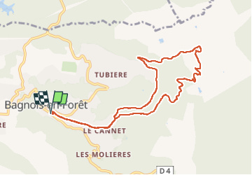

Length
10.3 km

Max alt
329 m

Uphill gradient
232 m
Km-Effort
13.4 km

Min alt
178 m

Downhill gradient
227 m
Boucle
Yes
Creation date :
2022-11-07 07:48:28.259
Updated on :
2022-11-07 10:59:29.28
3h09
Difficulty : Easy

FREE GPS app for hiking
 SityTrail
IGN / Geographical institutes
SityTrail Plus
The world is yours!
About
Trail Walking of 10.3 km to be discovered at Provence-Alpes-Côte d'Azur, Var, Bagnols-en-Forêt. This trail is proposed by ninia.
Positioning
Country:
France
Region :
Provence-Alpes-Côte d'Azur
Department/Province :
Var
Municipality :
Bagnols-en-Forêt
Location:
Unknown
Start:(Dec)
Start:(UTM)
314120 ; 4822920 (32T) N.
Comments