


Passenans -Bougelier

drarep
User
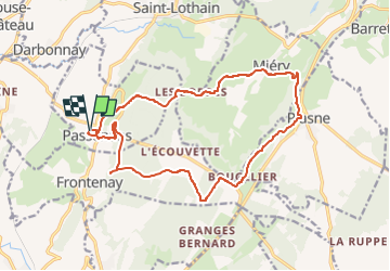

Length
17.3 km

Max alt
567 m

Uphill gradient
510 m
Km-Effort
24 km

Min alt
313 m

Downhill gradient
507 m
Boucle
Yes
Creation date :
2022-11-08 16:40:51.978
Updated on :
2022-11-08 16:51:34.626
5h17
Difficulty : Easy

FREE GPS app for hiking
 SityTrail
IGN / Geographical institutes
SityTrail Plus
The world is yours!
About
Trail Walking of 17.3 km to be discovered at Bourgogne-Franche-Comté, Jura, Passenans. This trail is proposed by drarep.
Positioning
Country:
France
Region :
Bourgogne-Franche-Comté
Department/Province :
Jura
Municipality :
Passenans
Location:
Unknown
Start:(Dec)
Start:(UTM)
699688 ; 5186064 (31T) N.
Comments