


Entre prés et garrigues

Mascart
User

Length
10.5 km

Max alt
480 m

Uphill gradient
225 m
Km-Effort
13.5 km

Min alt
295 m

Downhill gradient
211 m
Boucle
Yes
Creation date :
2022-11-08 12:42:04.429
Updated on :
2022-11-08 16:43:30.913
3h00
Difficulty : Medium

FREE GPS app for hiking
 SityTrail
IGN / Geographical institutes
SityTrail Plus
The world is yours!
About
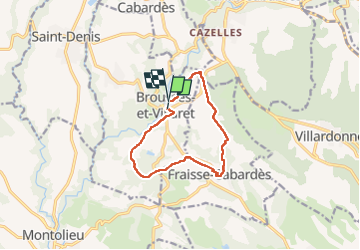
Trail Walking of 10.5 km to be discovered at Occitania, Aude, Brousses-et-Villaret. This trail is proposed by Mascart.
Description
brousses via fraisse
Positioning
Country:
France
Region :
Occitania
Department/Province :
Aude
Municipality :
Brousses-et-Villaret
Location:
Unknown
Start:(Dec)
Start:(UTM)
439539 ; 4799088 (31T) N.
Comments