


thenioux

lecmic
User
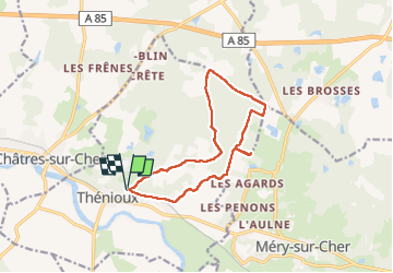

Length
12.3 km

Max alt
167 m

Uphill gradient
107 m
Km-Effort
13.7 km

Min alt
99 m

Downhill gradient
105 m
Boucle
Yes
Creation date :
2022-11-09 13:08:19.565
Updated on :
2022-11-09 16:10:22.714
3h01
Difficulty : Very easy

FREE GPS app for hiking
 SityTrail
IGN / Geographical institutes
SityTrail Plus
The world is yours!
About
Trail Walking of 12.3 km to be discovered at Centre-Loire Valley, Cher, Thénioux. This trail is proposed by lecmic.
Description
rando
Positioning
Country:
France
Region :
Centre-Loire Valley
Department/Province :
Cher
Municipality :
Thénioux
Location:
Unknown
Start:(Dec)
Start:(UTM)
419203 ; 5234374 (31T) N.
Comments