


grand colombier

Liebeaux
User
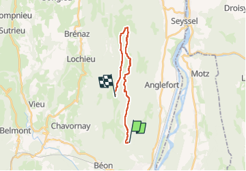

Length
17 km

Max alt
1512 m

Uphill gradient
664 m
Km-Effort
25 km

Min alt
1211 m

Downhill gradient
406 m
Boucle
No
Creation date :
2022-11-10 08:42:37.675
Updated on :
2022-11-10 14:24:18.498
5h41
Difficulty : Very difficult

FREE GPS app for hiking
 SityTrail
IGN / Geographical institutes
SityTrail Plus
The world is yours!
About
Trail Walking of 17 km to be discovered at Auvergne-Rhône-Alpes, Ain, Culoz. This trail is proposed by Liebeaux.
Positioning
Country:
France
Region :
Auvergne-Rhône-Alpes
Department/Province :
Ain
Municipality :
Culoz
Location:
Unknown
Start:(Dec)
Start:(UTM)
715442 ; 5083542 (31T) N.
Comments