


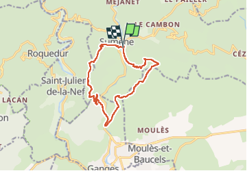
Ranc de Bane et les jumeaux

Roger Philippe Wallez
User GUIDE

Length
14.7 km

Max alt
693 m

Uphill gradient
793 m
Km-Effort
25 km

Min alt
169 m

Downhill gradient
790 m
Boucle
Yes
Creation date :
2022-11-10 09:02:16.0
Updated on :
2022-11-10 15:30:43.485
6h20
Difficulty : Very difficult

FREE GPS app for hiking
 SityTrail
IGN / Geographical institutes
SityTrail Plus
The world is yours!
About
Trail Walking of 14.7 km to be discovered at Occitania, Gard, Sumène. This trail is proposed by Roger Philippe Wallez.
Description
Sumène
Positioning
Country:
France
Region :
Occitania
Department/Province :
Gard
Municipality :
Sumène
Location:
Unknown
Start:(Dec)
Start:(UTM)
557527 ; 4869872 (31T) N.
Comments