


rando kayak

cess44
User
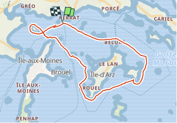

Length
19.8 km

Max alt
16 m

Uphill gradient
46 m
Km-Effort
20 km

Min alt
0 m

Downhill gradient
45 m
Boucle
Yes
Creation date :
2016-03-09 00:00:00.0
Updated on :
2016-03-09 00:00:00.0
7h03
Difficulty : Unknown

FREE GPS app for hiking
 SityTrail
IGN / Geographical institutes
SityTrail Plus
The world is yours!
About
Trail Other activity of 19.8 km to be discovered at Brittany, Morbihan, Arradon. This trail is proposed by cess44.
Positioning
Country:
France
Region :
Brittany
Department/Province :
Morbihan
Municipality :
Arradon
Location:
Unknown
Start:(Dec)
Start:(UTM)
512780 ; 5273485 (30T) N.
Comments