


2211_le_tour_de_la_gleizes

yt34
User
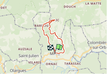

Length
11.2 km

Max alt
660 m

Uphill gradient
562 m
Km-Effort
18.7 km

Min alt
200 m

Downhill gradient
564 m
Boucle
Yes
Creation date :
2022-11-11 10:04:29.466
Updated on :
2022-11-14 08:30:47.555
3h19
Difficulty : Difficult

FREE GPS app for hiking
 SityTrail
IGN / Geographical institutes
SityTrail Plus
The world is yours!
About
Trail Walking of 11.2 km to be discovered at Occitania, Hérault, Mons. This trail is proposed by yt34.
Positioning
Country:
France
Region :
Occitania
Department/Province :
Hérault
Municipality :
Mons
Location:
Unknown
Start:(Dec)
Start:(UTM)
496494 ; 4824256 (31T) N.
Comments