


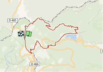
Ballon d'Alsace - cascade et lac d'Alfeld

Bart2015
User


2h17
Difficulty : Medium

FREE GPS app for hiking
 SityTrail
IGN / Geographical institutes
SityTrail Plus
The world is yours!
About
Trail Walking of 10.2 km to be discovered at Bourgogne-Franche-Comté, Territoire-de-Belfort, Lepuix. This trail is proposed by Bart2015.
Description
Rando au départ du Ballon d'Alsace pour redescendre au lac d'Alfeld en passant par la cascade, magnifique en période de pluies. Retour physique par le restaurant la Chaumière.
Bonne rando ...
Photos


25 photos in total. Please click on a photo to see them all in the gallery.
Positioning
Comments