


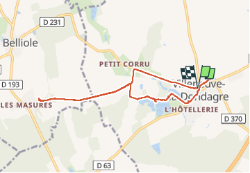
221112 Villeneuve la Dondagre-02 (geocaching)

Specialized77
User GUIDE

Length
8.3 km

Max alt
191 m

Uphill gradient
62 m
Km-Effort
9.1 km

Min alt
165 m

Downhill gradient
60 m
Boucle
Yes
Creation date :
2022-11-12 07:33:52.873
Updated on :
2022-11-12 17:45:05.607
3h19
Difficulty : Easy

FREE GPS app for hiking
 SityTrail
IGN / Geographical institutes
SityTrail Plus
The world is yours!
About
Trail Geocaching of 8.3 km to be discovered at Bourgogne-Franche-Comté, Yonne, Villeneuve-la-Dondagre. This trail is proposed by Specialized77.
Description
2ème partie du circuit geocaching
Positioning
Country:
France
Region :
Bourgogne-Franche-Comté
Department/Province :
Yonne
Municipality :
Villeneuve-la-Dondagre
Location:
Unknown
Start:(Dec)
Start:(UTM)
510117 ; 5331741 (31U) N.
Comments