


12/11/2022 - Variante au sud Chapelle de Gavrain.Virtuel

babeth35
User
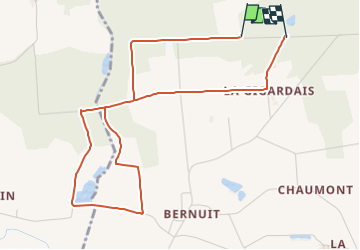

Length
4.8 km

Max alt
77 m

Uphill gradient
61 m
Km-Effort
5.7 km

Min alt
25 m

Downhill gradient
65 m
Boucle
No
Creation date :
2022-11-12 16:39:36.427
Updated on :
2022-11-12 17:27:51.029
1h53
Difficulty : Easy
1h53
Difficulty : Medium

FREE GPS app for hiking
 SityTrail
IGN / Geographical institutes
SityTrail Plus
The world is yours!
About
Trail On foot of 4.8 km to be discovered at Brittany, Ille-et-Vilaine, Langon. This trail is proposed by babeth35.
Positioning
Country:
France
Region :
Brittany
Department/Province :
Ille-et-Vilaine
Municipality :
Langon
Location:
Unknown
Start:(Dec)
Start:(UTM)
582013 ; 5287330 (30T) N.
Comments