


Pointe de surgate

chasle
User
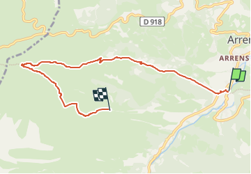

Length
7.4 km

Max alt
1813 m

Uphill gradient
933 m
Km-Effort
16.8 km

Min alt
891 m

Downhill gradient
38 m
Boucle
No
Creation date :
2022-11-12 17:47:45.397
Updated on :
2022-11-12 17:48:28.25
3h49
Difficulty : Medium

FREE GPS app for hiking
 SityTrail
IGN / Geographical institutes
SityTrail Plus
The world is yours!
About
Trail Walking of 7.4 km to be discovered at Occitania, Hautespyrenees, Arrens-Marsous. This trail is proposed by chasle.
Positioning
Country:
France
Region :
Occitania
Department/Province :
Hautespyrenees
Municipality :
Arrens-Marsous
Location:
Unknown
Start:(Dec)
Start:(UTM)
727102 ; 4759055 (30T) N.
Comments