


12/11/2022 - ST GANTON sentier interpretation.virtuel

babeth35
User
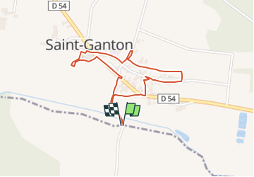

Length
1.8 km

Max alt
85 m

Uphill gradient
34 m
Km-Effort
2.3 km

Min alt
52 m

Downhill gradient
33 m
Boucle
Yes
Creation date :
2022-11-12 18:29:10.529
Updated on :
2022-11-12 18:33:31.319
31m
Difficulty : Easy
31m
Difficulty : Easy

FREE GPS app for hiking
 SityTrail
IGN / Geographical institutes
SityTrail Plus
The world is yours!
About
Trail On foot of 1.8 km to be discovered at Brittany, Ille-et-Vilaine, Langon. This trail is proposed by babeth35.
Positioning
Country:
France
Region :
Brittany
Department/Province :
Ille-et-Vilaine
Municipality :
Langon
Location:
Unknown
Start:(Dec)
Start:(UTM)
583757 ; 5289307 (30T) N.
Comments