


lestrem benb 13.11.2022

eaea7charles
User
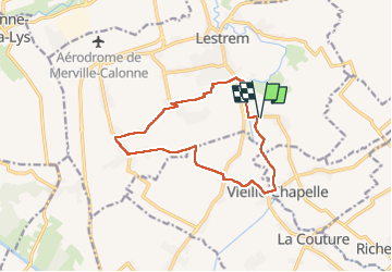

Length
11.6 km

Max alt
21 m

Uphill gradient
43 m
Km-Effort
12.2 km

Min alt
14 m

Downhill gradient
43 m
Boucle
Yes
Creation date :
2022-11-13 07:52:44.882
Updated on :
2022-11-13 10:48:02.634
2h36
Difficulty : Difficult

FREE GPS app for hiking
 SityTrail
IGN / Geographical institutes
SityTrail Plus
The world is yours!
About
Trail Walking of 11.6 km to be discovered at Hauts-de-France, Pas-de-Calais, Lestrem. This trail is proposed by eaea7charles.
Photos

Positioning
Country:
France
Region :
Hauts-de-France
Department/Province :
Pas-de-Calais
Municipality :
Lestrem
Location:
Unknown
Start:(Dec)
Start:(UTM)
478638 ; 5606007 (31U) N.
Comments