


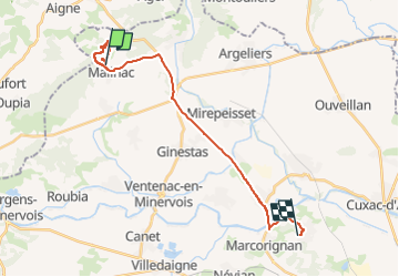
Mailhac

crognon
User

Length
22 km

Max alt
136 m

Uphill gradient
205 m
Km-Effort
25 km

Min alt
14 m

Downhill gradient
227 m
Boucle
No
Creation date :
2022-11-13 09:51:00.569
Updated on :
2022-11-13 14:12:18.389
4h20
Difficulty : Very easy

FREE GPS app for hiking
 SityTrail
IGN / Geographical institutes
SityTrail Plus
The world is yours!
About
Trail Walking of 22 km to be discovered at Occitania, Aude, Mailhac. This trail is proposed by crognon.
Positioning
Country:
France
Region :
Occitania
Department/Province :
Aude
Municipality :
Mailhac
Location:
Unknown
Start:(Dec)
Start:(UTM)
485781 ; 4794883 (31T) N.
Comments