


Sougraigne source eau salée fours de verriers

Ada11
User GUIDE
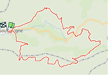

Length
17.4 km

Max alt
817 m

Uphill gradient
674 m
Km-Effort
26 km

Min alt
393 m

Downhill gradient
672 m
Boucle
Yes
Creation date :
2022-11-13 08:40:16.086
Updated on :
2022-11-13 15:27:32.931
4h32
Difficulty : Medium

FREE GPS app for hiking
 SityTrail
IGN / Geographical institutes
SityTrail Plus
The world is yours!
About
Trail Walking of 17.4 km to be discovered at Occitania, Aude, Sougraigne. This trail is proposed by Ada11.
Description
Manque un bout après la source après le pique nique. En descendant vers Sougraigne, conserver toujours le chemin balisé en jaune, c'est plus court.
Positioning
Country:
France
Region :
Occitania
Department/Province :
Aude
Municipality :
Sougraigne
Location:
Unknown
Start:(Dec)
Start:(UTM)
447146 ; 4750053 (31T) N.
Comments