


BALVEURCHE

surceneux
User
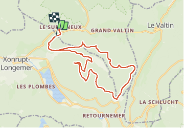

Length
18.5 km

Max alt
1081 m

Uphill gradient
402 m
Km-Effort
24 km

Min alt
807 m

Downhill gradient
410 m
Boucle
No
Creation date :
2022-08-14 07:56:50.188
Updated on :
2022-11-13 20:02:48.317
1h45
Difficulty : Medium

FREE GPS app for hiking
 SityTrail
IGN / Geographical institutes
SityTrail Plus
The world is yours!
About
Trail Mountain bike of 18.5 km to be discovered at Grand Est, Vosges, Xonrupt-Longemer. This trail is proposed by surceneux.
Description
TOUR DE BALVEURCHE VARIANTE
Positioning
Country:
France
Region :
Grand Est
Department/Province :
Vosges
Municipality :
Xonrupt-Longemer
Location:
Unknown
Start:(Dec)
Start:(UTM)
347608 ; 5328678 (32U) N.
Comments