


AUTOUR DE LA CASCADE DE NIDECK

surceneux
User
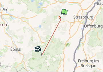

Length
71 km

Max alt
1048 m

Uphill gradient
5008 m
Km-Effort
137 km

Min alt
247 m

Downhill gradient
4660 m
Boucle
No
Creation date :
2022-11-13 09:53:08.069
Updated on :
2022-11-13 20:02:58.209
3h45
Difficulty : Easy

FREE GPS app for hiking
 SityTrail
IGN / Geographical institutes
SityTrail Plus
The world is yours!
About
Trail Walking of 71 km to be discovered at Grand Est, Bas-Rhin, Oberhaslach. This trail is proposed by surceneux.
Positioning
Country:
France
Region :
Grand Est
Department/Province :
Bas-Rhin
Municipality :
Oberhaslach
Location:
Unknown
Start:(Dec)
Start:(UTM)
375413 ; 5380774 (32U) N.
Comments