


figuerolles.jacky

NADINE52
User
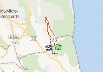

Length
5.1 km

Max alt
84 m

Uphill gradient
49 m
Km-Effort
5.8 km

Min alt
51 m

Downhill gradient
48 m
Boucle
Yes
Creation date :
2022-11-15 11:06:14.73
Updated on :
2022-11-15 13:25:49.819
1h21
Difficulty : Easy

FREE GPS app for hiking
 SityTrail
IGN / Geographical institutes
SityTrail Plus
The world is yours!
About
Trail Walking of 5.1 km to be discovered at Provence-Alpes-Côte d'Azur, Bouches-du-Rhône, Martigues. This trail is proposed by NADINE52.
Positioning
Country:
France
Region :
Provence-Alpes-Côte d'Azur
Department/Province :
Bouches-du-Rhône
Municipality :
Martigues
Location:
Unknown
Start:(Dec)
Start:(UTM)
665344 ; 4811208 (31T) N.
Comments