


Campan Randonnée

philou6351
User
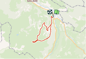

Length
14.2 km

Max alt
1888 m

Uphill gradient
1045 m
Km-Effort
28 km

Min alt
852 m

Downhill gradient
1046 m
Boucle
Yes
Creation date :
2022-11-16 12:09:33.21
Updated on :
2022-11-16 12:16:30.581
4h30
Difficulty : Medium

FREE GPS app for hiking
 SityTrail
IGN / Geographical institutes
SityTrail Plus
The world is yours!
About
Trail Walking of 14.2 km to be discovered at Occitania, Hautespyrenees, Campan. This trail is proposed by philou6351.
Positioning
Country:
France
Region :
Occitania
Department/Province :
Hautespyrenees
Municipality :
Campan
Location:
Unknown
Start:(Dec)
Start:(UTM)
273924 ; 4762838 (31T) N.
Comments