


Collebasse Croix Valmer

aljac
User
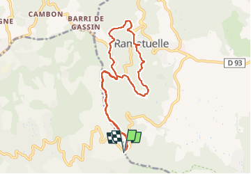

Length
9.3 km

Max alt
273 m

Uphill gradient
279 m
Km-Effort
13.1 km

Min alt
117 m

Downhill gradient
278 m
Boucle
Yes
Creation date :
2022-11-16 09:56:32.49
Updated on :
2022-11-16 14:13:17.818
4h16
Difficulty : Very easy

FREE GPS app for hiking
 SityTrail
IGN / Geographical institutes
SityTrail Plus
The world is yours!
About
Trail Walking of 9.3 km to be discovered at Provence-Alpes-Côte d'Azur, Var, Ramatuelle. This trail is proposed by aljac.
Positioning
Country:
France
Region :
Provence-Alpes-Côte d'Azur
Department/Province :
Var
Municipality :
Ramatuelle
Location:
Unknown
Start:(Dec)
Start:(UTM)
305704 ; 4785296 (32T) N.
Comments