


Malataverne - Soustelle

JMJ42
User
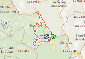

Length
15.8 km

Max alt
459 m

Uphill gradient
566 m
Km-Effort
23 km

Min alt
155 m

Downhill gradient
566 m
Boucle
Yes
Creation date :
2022-10-18 07:33:27.623
Updated on :
2022-11-17 12:20:38.535
4h20
Difficulty : Difficult

FREE GPS app for hiking
 SityTrail
IGN / Geographical institutes
SityTrail Plus
The world is yours!
About
Trail Walking of 15.8 km to be discovered at Occitania, Gard, Cendras. This trail is proposed by JMJ42.
Positioning
Country:
France
Region :
Occitania
Department/Province :
Gard
Municipality :
Cendras
Location:
Unknown
Start:(Dec)
Start:(UTM)
582510 ; 4889871 (31T) N.
Comments