


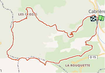
Cabrières (les Crozes, Soureille d'Izarne)

coulombf
User

Length
16.6 km

Max alt
363 m

Uphill gradient
574 m
Km-Effort
24 km

Min alt
102 m

Downhill gradient
576 m
Boucle
Yes
Creation date :
2022-11-17 08:13:57.0
Updated on :
2022-11-17 20:09:05.514
6h25
Difficulty : Difficult

FREE GPS app for hiking
 SityTrail
IGN / Geographical institutes
SityTrail Plus
The world is yours!
About
Trail Walking of 16.6 km to be discovered at Occitania, Hérault, Cabrières. This trail is proposed by coulombf.
Description
17/11/2022 groupe marche FC
D'aprés la Randonnée Cévenole
Positioning
Country:
France
Region :
Occitania
Department/Province :
Hérault
Municipality :
Cabrières
Location:
Unknown
Start:(Dec)
Start:(UTM)
529346 ; 4824471 (31T) N.
Comments