


20221118 Benodet

Childebert
User
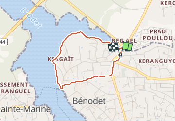

Length
2.9 km

Max alt
27 m

Uphill gradient
36 m
Km-Effort
3.4 km

Min alt
-1 m

Downhill gradient
36 m
Boucle
Yes
Creation date :
2022-11-18 13:10:22.576
Updated on :
2022-11-18 14:07:28.301
56m
Difficulty : Easy

FREE GPS app for hiking
 SityTrail
IGN / Geographical institutes
SityTrail Plus
The world is yours!
About
Trail Walking of 2.9 km to be discovered at Brittany, Finistère, Bénodet. This trail is proposed by Childebert.
Description
pluie
Positioning
Country:
France
Region :
Brittany
Department/Province :
Finistère
Municipality :
Bénodet
Location:
Unknown
Start:(Dec)
Start:(UTM)
417354 ; 5303528 (30T) N.
Comments