Trail Other activity Nesslau - y10_thur_nesslau - Photo

Optez pour le retour à la nature GUIDE+
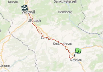
© OpenStreetMap contributors
Length
Length
14.6 km
Max alt
Max alt
769 m
Uphill gradient
Uphill gradient
100 m
Km-Effort
Km-Effort  
16.5 km
Min alt
Min alt
611 m
Downhill gradient
Downhill gradient
246 m
Boucle
Boucle
No
Creation date :
2014-12-10 00:00:00.0
Updated on :
2014-12-10 00:00:00.0

(0 Reviews)

Other activity
Other activity
3h59
Difficulty : Unknown

Scan this QR Code to open this trail in the SityTrail application

FREE GPS app for hiking

Logo SityTrail SityTrail

IGN / Geographical institutes

Download SityTrail from the App Store Download SityTrail from Google Play

Logo SityTrail SityTrail Plus

The world is yours!

Download SityTrail from the App Store Download SityTrail from Google Play Download SityTrail on Huawei AppGallery

About

Trail Other activity of 14.6 km to be discovered at Sankt Gallen, Wahlkreis Toggenburg, Nesslau. This trail is proposed by My Switzerland.

Elevation profile

Points of interest

Point of interest Wattwil - Bahnhof Wattwil - Photo
My Switzerland
Point of interest Nesslau - Bahnhof Nesslau - Photo
My Switzerland
Point of interest Nesslau - Krummenau - Photo
My Switzerland
NESSLAU 
Point of interest Ebnat-Kappel - Bahnhof Ebnat-Kappel - Photo
My Switzerland
EBNAT-KAPPEL 

Positioning

Country:
Switzerland
Region :
Sankt Gallen
Department/Province :
Wahlkreis Toggenburg
Municipality :
Nesslau
Location:
Unknown
Start:(UTM)
514958 ; 5230437 (32T) N.


Close
My subscriptions