


2022-11-20_08h19m25_randuro-vtt-37km-allridevttluberon2022-officiel

hollier-larousse
User
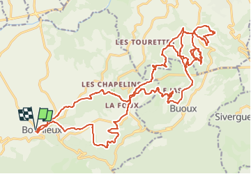

Length
36 km

Max alt
542 m

Uphill gradient
1277 m
Km-Effort
53 km

Min alt
308 m

Downhill gradient
1277 m
Boucle
Yes
Creation date :
2022-11-20 07:19:26.132
Updated on :
2022-11-20 07:19:29.081

FREE GPS app for hiking
 SityTrail
IGN / Geographical institutes
SityTrail Plus
The world is yours!
About
Trail of 36 km to be discovered at Provence-Alpes-Côte d'Azur, Vaucluse, Bonnieux. This trail is proposed by hollier-larousse.
Description
Total: 37.0km
Positioning
Country:
France
Region :
Provence-Alpes-Côte d'Azur
Department/Province :
Vaucluse
Municipality :
Bonnieux
Location:
Unknown
Start:(Dec)
Start:(UTM)
685358 ; 4854849 (31T) N.
Comments