


contadour 3

dumotier
User

Length
16.8 km

Max alt
1427 m

Uphill gradient
514 m
Km-Effort
24 km

Min alt
1090 m

Downhill gradient
516 m
Boucle
Yes
Creation date :
2022-11-20 07:46:54.007
Updated on :
2022-11-20 12:53:46.276
4h07
Difficulty : Very difficult

FREE GPS app for hiking
 SityTrail
IGN / Geographical institutes
SityTrail Plus
The world is yours!
About
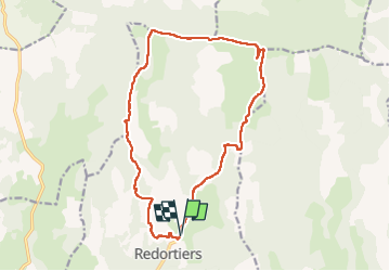
Trail Walking of 16.8 km to be discovered at Provence-Alpes-Côte d'Azur, Alpes-de-Haute-Provence, Redortiers. This trail is proposed by dumotier.
Positioning
Country:
France
Region :
Provence-Alpes-Côte d'Azur
Department/Province :
Alpes-de-Haute-Provence
Municipality :
Redortiers
Location:
Unknown
Start:(Dec)
Start:(UTM)
709750 ; 4886983 (31T) N.
Comments