


WET 2023 Markstein --> Gerardmer J3

bolley_c_d_m
User
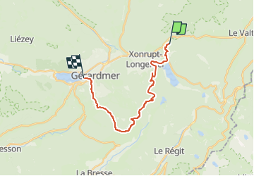

Length
17.6 km

Max alt
1093 m

Uphill gradient
514 m
Km-Effort
25 km

Min alt
663 m

Downhill gradient
661 m
Boucle
No
Creation date :
2022-11-20 20:51:51.621
Updated on :
2023-02-26 14:04:26.072
0m
Difficulty : Very easy

FREE GPS app for hiking
 SityTrail
IGN / Geographical institutes
SityTrail Plus
The world is yours!
About
Trail Trail of 17.6 km to be discovered at Grand Est, Vosges, Xonrupt-Longemer. This trail is proposed by bolley_c_d_m.
Positioning
Country:
France
Region :
Grand Est
Department/Province :
Vosges
Municipality :
Xonrupt-Longemer
Location:
Unknown
Start:(Dec)
Start:(UTM)
347365 ; 5328448 (32U) N.
Comments