


Lavernay

dcharbonnier
User
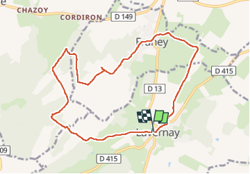

Length
9.5 km

Max alt
272 m

Uphill gradient
154 m
Km-Effort
11.6 km

Min alt
207 m

Downhill gradient
162 m
Boucle
Yes
Creation date :
2022-11-21 12:29:34.106
Updated on :
2022-11-21 15:06:45.782
2h36
Difficulty : Medium

FREE GPS app for hiking
 SityTrail
IGN / Geographical institutes
SityTrail Plus
The world is yours!
About
Trail Walking of 9.5 km to be discovered at Bourgogne-Franche-Comté, Doubs, Lavernay. This trail is proposed by dcharbonnier.
Description
fontaine
Positioning
Country:
France
Region :
Bourgogne-Franche-Comté
Department/Province :
Doubs
Municipality :
Lavernay
Location:
Unknown
Start:(Dec)
Start:(UTM)
713147 ; 5236369 (31T) N.
Comments