


Col de l'Evéque - Pic de l'Ours

soca
User

Length
9.2 km

Max alt
429 m

Uphill gradient
595 m
Km-Effort
17.1 km

Min alt
26 m

Downhill gradient
595 m
Boucle
Yes
Creation date :
2022-11-21 19:26:59.975
Updated on :
2022-11-21 19:37:31.512
5h00
Difficulty : Difficult

FREE GPS app for hiking
 SityTrail
IGN / Geographical institutes
SityTrail Plus
The world is yours!
About
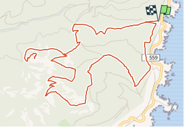
Trail Walking of 9.2 km to be discovered at Provence-Alpes-Côte d'Azur, Var, Saint-Raphaël. This trail is proposed by soca.
Description
Départ Calanque d'Aurelle - Col de l'Evêque - Grotte chapelle St Honoré - Retour En dessous du Pilon - pointe de Maubois - Calanque d'Aurelle
Positioning
Country:
France
Region :
Provence-Alpes-Côte d'Azur
Department/Province :
Var
Municipality :
Saint-Raphaël
Location:
Unknown
Start:(Dec)
Start:(UTM)
331808 ; 4814184 (32T) N.
Comments