


LURS LE TOUR DE LURS

RobinMicheline
User GUIDE
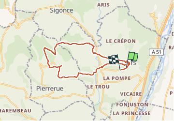

Length
16 km

Max alt
580 m

Uphill gradient
419 m
Km-Effort
22 km

Min alt
408 m

Downhill gradient
435 m
Boucle
No
Creation date :
2022-11-22 07:35:34.991
Updated on :
2022-11-22 14:12:16.078
5h25
Difficulty : Difficult

FREE GPS app for hiking
 SityTrail
IGN / Geographical institutes
SityTrail Plus
The world is yours!
About
Trail Walking of 16 km to be discovered at Provence-Alpes-Côte d'Azur, Alpes-de-Haute-Provence, Lurs. This trail is proposed by RobinMicheline.
Positioning
Country:
France
Region :
Provence-Alpes-Côte d'Azur
Department/Province :
Alpes-de-Haute-Provence
Municipality :
Lurs
Location:
Unknown
Start:(Dec)
Start:(UTM)
731627 ; 4872218 (31T) N.
Comments