


boucle Aix la Chapelle

Lychee
User
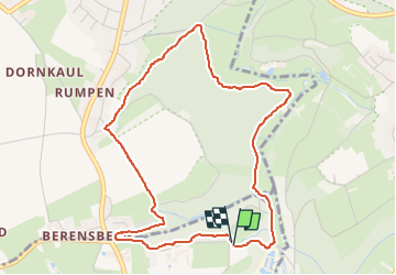

Length
4.5 km

Max alt
194 m

Uphill gradient
69 m
Km-Effort
5.4 km

Min alt
138 m

Downhill gradient
62 m
Boucle
Yes
Creation date :
2022-11-22 14:11:51.401
Updated on :
2022-11-22 15:29:48.507
1h16
Difficulty : Easy

FREE GPS app for hiking
 SityTrail
IGN / Geographical institutes
SityTrail Plus
The world is yours!
About
Trail Walking of 4.5 km to be discovered at North Rhine-Westphalia, Städteregion Aachen, Aachen. This trail is proposed by Lychee.
Positioning
Country:
Germany
Region :
North Rhine-Westphalia
Department/Province :
Städteregion Aachen
Municipality :
Aachen
Location:
Laurensberg
Start:(Dec)
Start:(UTM)
295810 ; 5632731 (32U) N.
Comments