


Landeyron Fecles

HB01
User
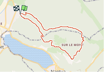

Length
9.5 km

Max alt
902 m

Uphill gradient
431 m
Km-Effort
15.3 km

Min alt
493 m

Downhill gradient
426 m
Boucle
Yes
Creation date :
2022-11-24 08:56:32.676
Updated on :
2022-11-24 13:12:13.269
2h54
Difficulty : Easy

FREE GPS app for hiking
 SityTrail
IGN / Geographical institutes
SityTrail Plus
The world is yours!
About
Trail Walking of 9.5 km to be discovered at Auvergne-Rhône-Alpes, Ain, Montréal-la-Cluse. This trail is proposed by HB01.
Description
Départ Montréal
Positioning
Country:
France
Region :
Auvergne-Rhône-Alpes
Department/Province :
Ain
Municipality :
Montréal-la-Cluse
Location:
Unknown
Start:(Dec)
Start:(UTM)
699401 ; 5116946 (31T) N.
Comments