


St Julien de ratz

Liebeaux
User
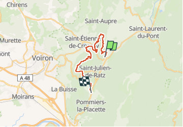

Length
17.5 km

Max alt
717 m

Uphill gradient
736 m
Km-Effort
27 km

Min alt
420 m

Downhill gradient
599 m
Boucle
No
Creation date :
2022-11-24 08:17:12.95
Updated on :
2022-11-24 14:49:34.224
6h31
Difficulty : Very difficult

FREE GPS app for hiking
 SityTrail
IGN / Geographical institutes
SityTrail Plus
The world is yours!
About
Trail Walking of 17.5 km to be discovered at Auvergne-Rhône-Alpes, Isère, Saint-Joseph-de-Rivière. This trail is proposed by Liebeaux.
Positioning
Country:
France
Region :
Auvergne-Rhône-Alpes
Department/Province :
Isère
Municipality :
Saint-Joseph-de-Rivière
Location:
Unknown
Start:(Dec)
Start:(UTM)
709579 ; 5026840 (31T) N.
Comments