


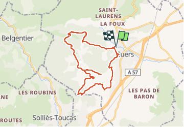
Cuers les Regagnades

Yot
User

Length
17.8 km

Max alt
435 m

Uphill gradient
676 m
Km-Effort
27 km

Min alt
150 m

Downhill gradient
677 m
Boucle
Yes
Creation date :
2022-11-24 08:04:57.116
Updated on :
2022-11-24 15:21:45.509
6h27
Difficulty : Medium

FREE GPS app for hiking
 SityTrail
IGN / Geographical institutes
SityTrail Plus
The world is yours!
About
Trail Walking of 17.8 km to be discovered at Provence-Alpes-Côte d'Azur, Var, Cuers. This trail is proposed by Yot.
Positioning
Country:
France
Region :
Provence-Alpes-Côte d'Azur
Department/Province :
Var
Municipality :
Cuers
Location:
Unknown
Start:(Dec)
Start:(UTM)
261866 ; 4791701 (32T) N.
Comments