


champey

jacthiry
User
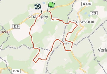

Length
8.8 km

Max alt
462 m

Uphill gradient
237 m
Km-Effort
11.9 km

Min alt
352 m

Downhill gradient
239 m
Boucle
No
Creation date :
2022-11-24 12:51:04.403
Updated on :
2022-11-24 15:34:14.823
2h42
Difficulty : Medium

FREE GPS app for hiking
 SityTrail
IGN / Geographical institutes
SityTrail Plus
The world is yours!
About
Trail Walking of 8.8 km to be discovered at Bourgogne-Franche-Comté, Haute-Saône, Champey. This trail is proposed by jacthiry.
Positioning
Country:
France
Region :
Bourgogne-Franche-Comté
Department/Province :
Haute-Saône
Municipality :
Champey
Location:
Unknown
Start:(Dec)
Start:(UTM)
325991 ; 5272958 (32T) N.
Comments