


bourdons-sur-rognon (1)

irenep52
User
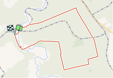

Length
10.2 km

Max alt
390 m

Uphill gradient
157 m
Km-Effort
12.3 km

Min alt
268 m

Downhill gradient
158 m
Boucle
Yes
Creation date :
2022-11-26 13:24:05.49
Updated on :
2024-06-07 17:30:03.716
2h47
Difficulty : Easy

FREE GPS app for hiking
 SityTrail
IGN / Geographical institutes
SityTrail Plus
The world is yours!
About
Trail On foot of 10.2 km to be discovered at Grand Est, Haute-Marne, Bourdons-sur-Rognon. This trail is proposed by irenep52.
Positioning
Country:
France
Region :
Grand Est
Department/Province :
Haute-Marne
Municipality :
Bourdons-sur-Rognon
Location:
Unknown
Start:(Dec)
Start:(UTM)
672016 ; 5342176 (31U) N.
Comments